Wellcome to National Portal
বাংলাদেশ ভূতাত্ত্বিক জরিপ অধিদপ্তর
জ্বালানি ও খনিজ সম্পদ বিভাগ
Text size
A
A
A
Color
C
C
C
C
সর্ব-শেষ হাল-নাগাদ: ১৭ জুলাই ২০২৩
GeoUPAC প্রকল্প কর্তৃক প্রণীত মানচিত্রসমূহ
| ক্রমিক | মানচিত্রের নাম (ফরিদপুর জোন ) | ভিউ/ ডাউনলোড |
| ১। | Local Peak Ground Acceleration (LPGA) Map of Faridpur Town and Surrounding Area | 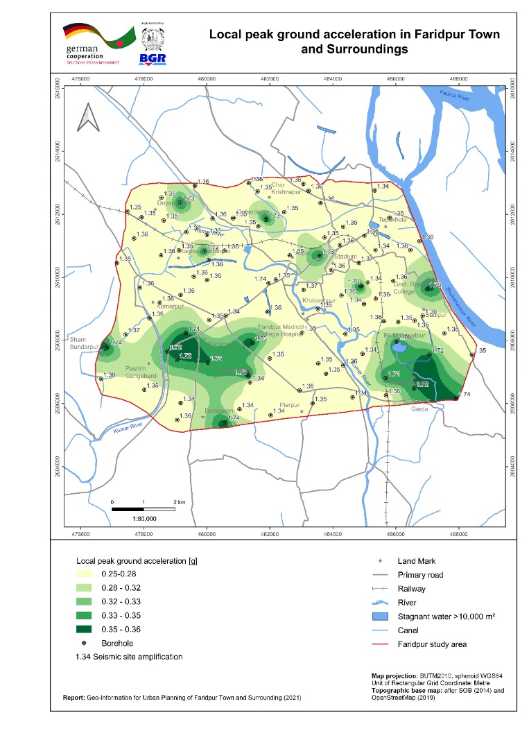 |
| ২। | Bearing Capacity Maps (shallow and deep foundation) of Faridpur Town and Surrounding Area |  |
| ৩। | Liquefaction Potential Index (sLPI) Map of Faridpur Town and Surrounding Area | 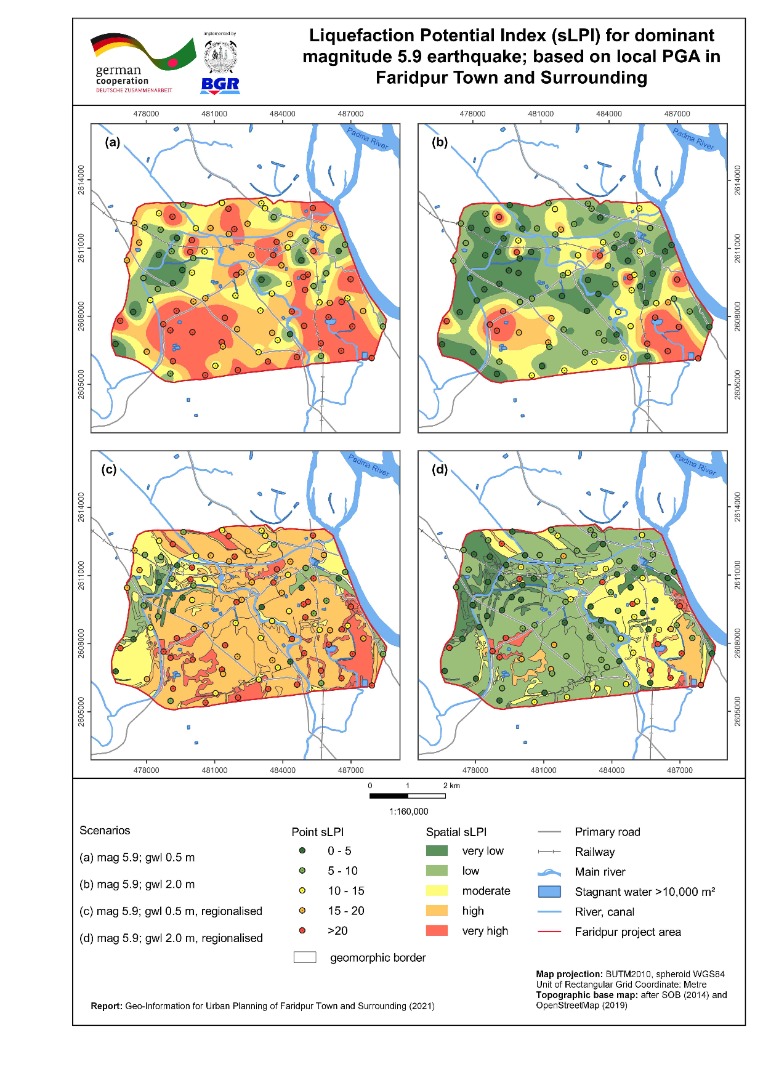 |
| ৪। | Seismic Site Class Map (Vs30) of Faridpur Town and Surrounding Area | 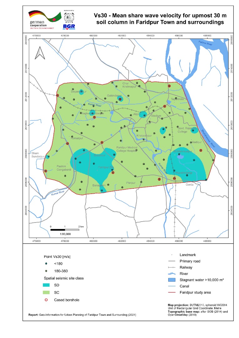 |
| ৫। | Geomorphic Map of Faridpur Town and Surrounding Area | 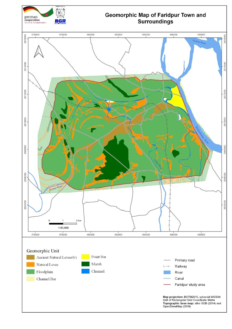 |
| ৬। | Inundation Map of Faridpur Town and Surrounding Area | 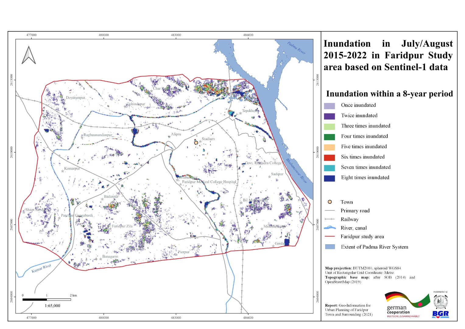 |
| ৭। | Land Use Map of Faridpur Town and Surrounding Area | 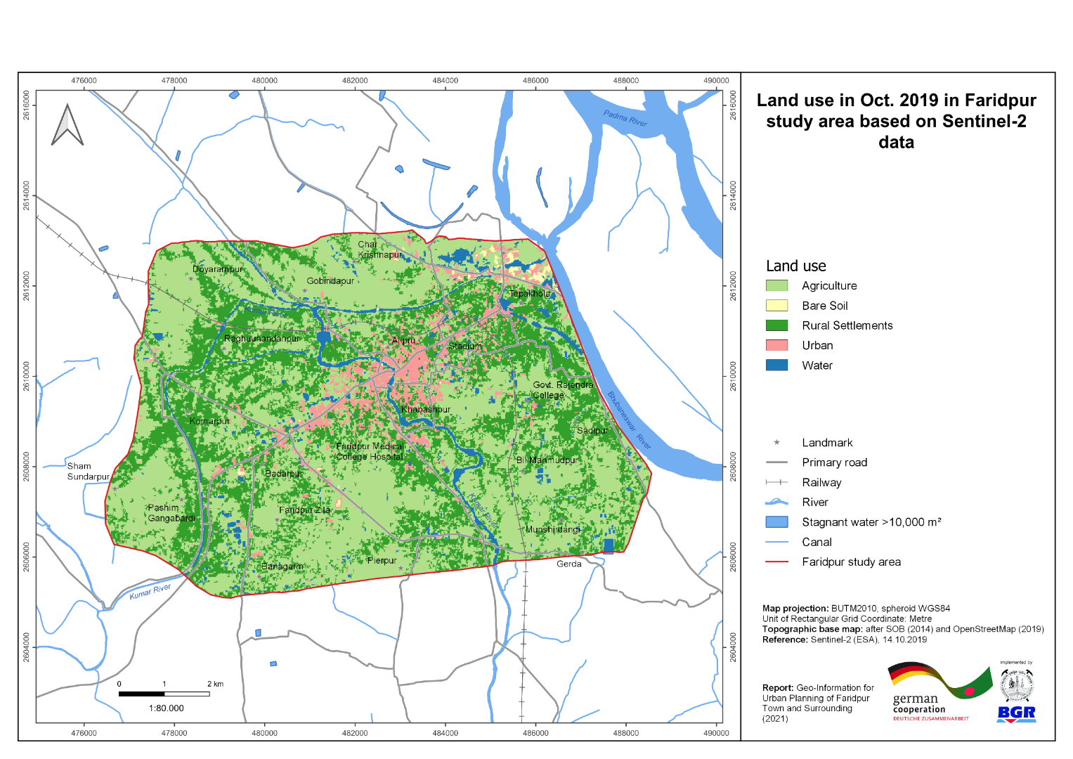 |
| ৮। | River Course Change Detection Map of Faridpur Town and Surrounding Area |  |
| ৯। | Vertical Ground Motion Map of Faridpur Town and Surrounding Area |  |
| ১০। | 3-D geological Model with cross-section of Faridpur Town and Surrounding Area |  |
| ১১। | Building Ground Suitability Map of Faridpur Town and Surroundings |  |
| ক্রমিক | মানচিত্রের নাম (বরিশাল জোন ) | ভিউ/ ডাউনলোড |
| ১। | Local Peak Ground Acceleration (LPGA) Map of Barishal Town and Surrounding Area | 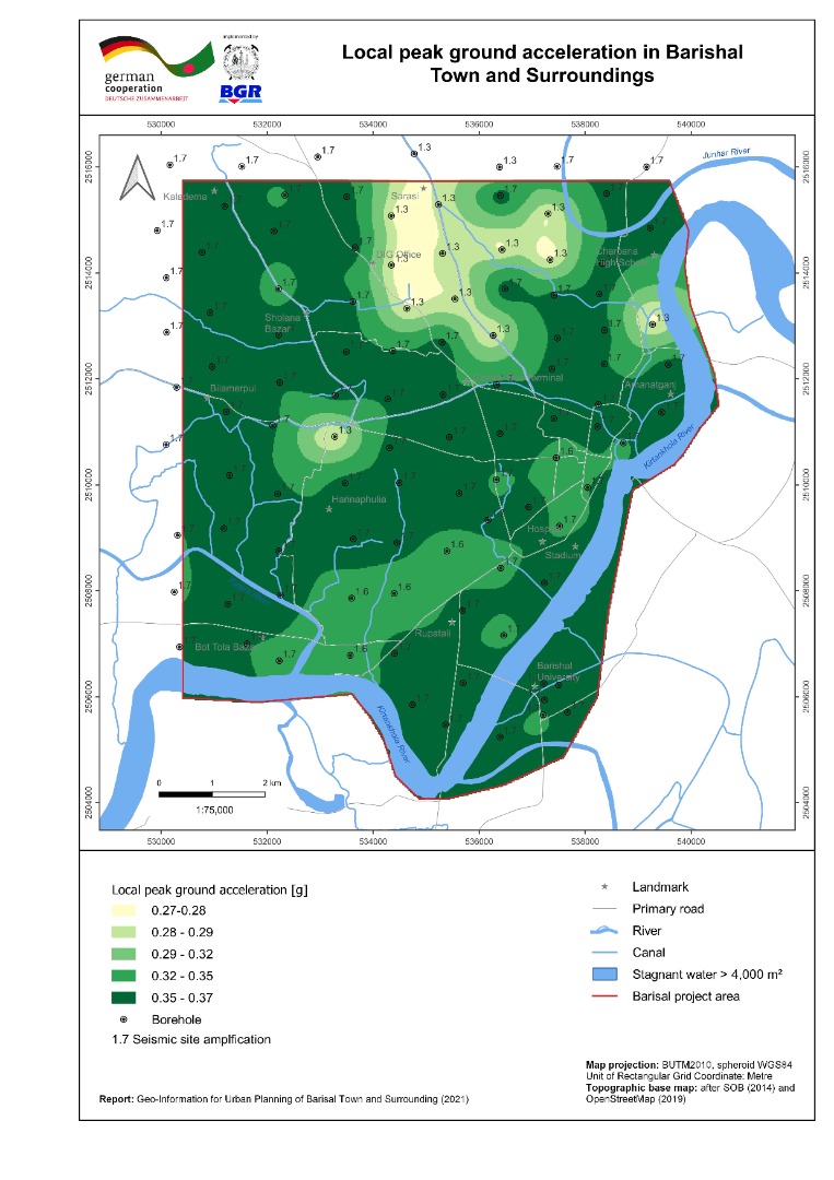 |
| ২। | Bearing Capacity Maps (shallow and deep foundation) of Barishal Town and Surrounding Area | 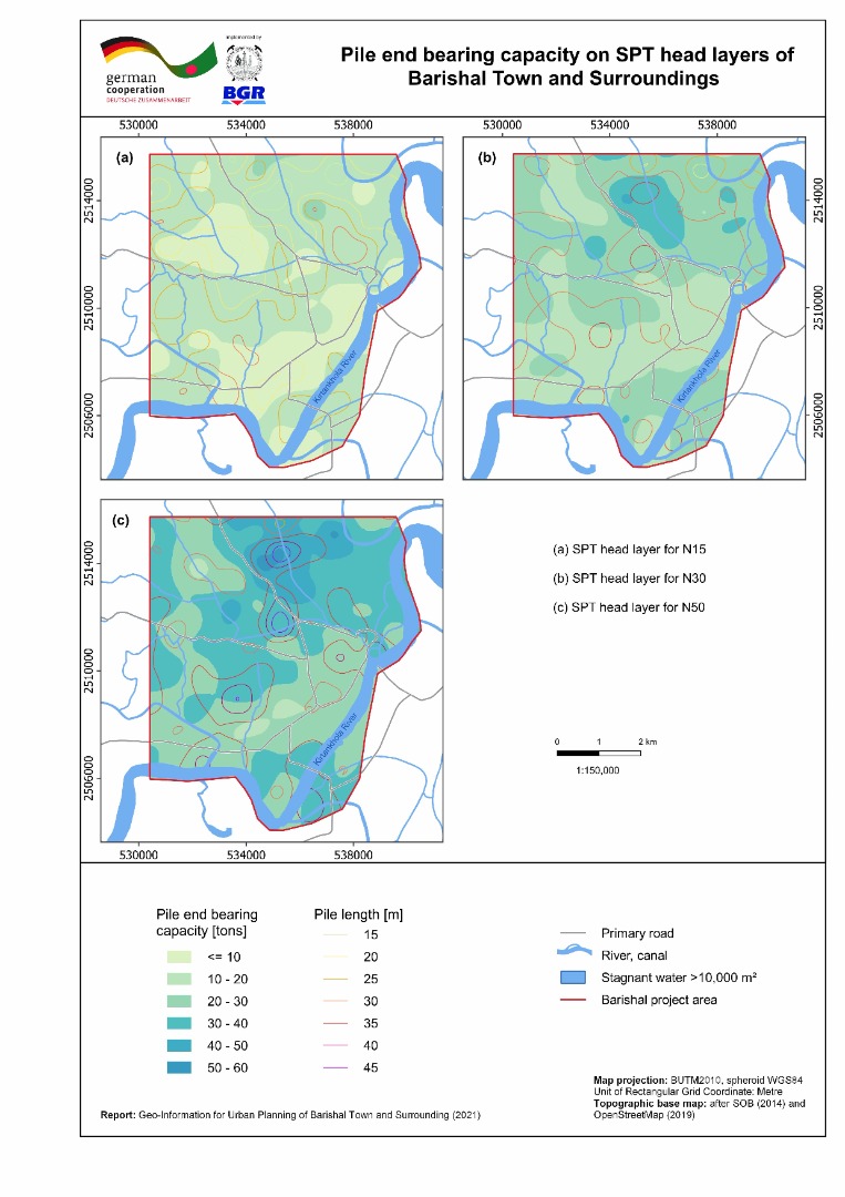 |
| ৩। | Liquefaction Potential Index (sLPI) Map of Barishal Town and Surrounding Area | 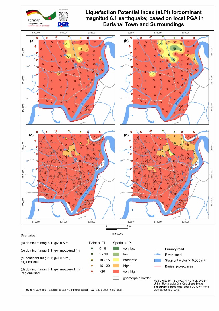 |
| ৪। | Seismic Site Class Map (Vs30) of Barishal Town and Surrounding Area | 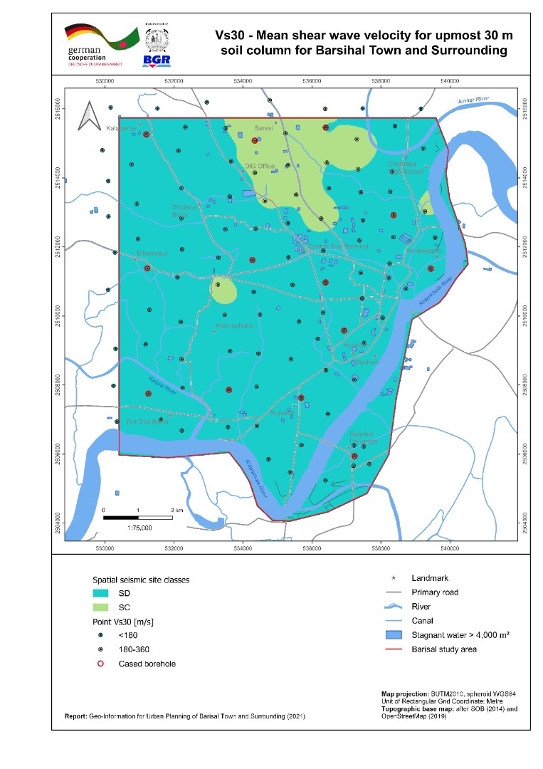 |
| ৫। | Geomorphic Map of Barishal Town and Surrounding Area |  |
| ৬। | Inundation Map of Barishal Town and Surrounding Area | 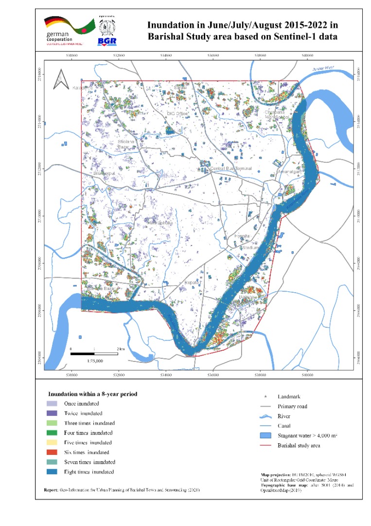 |
| ৭। | Land Use Map of Barishal Town and Surrounding Area | 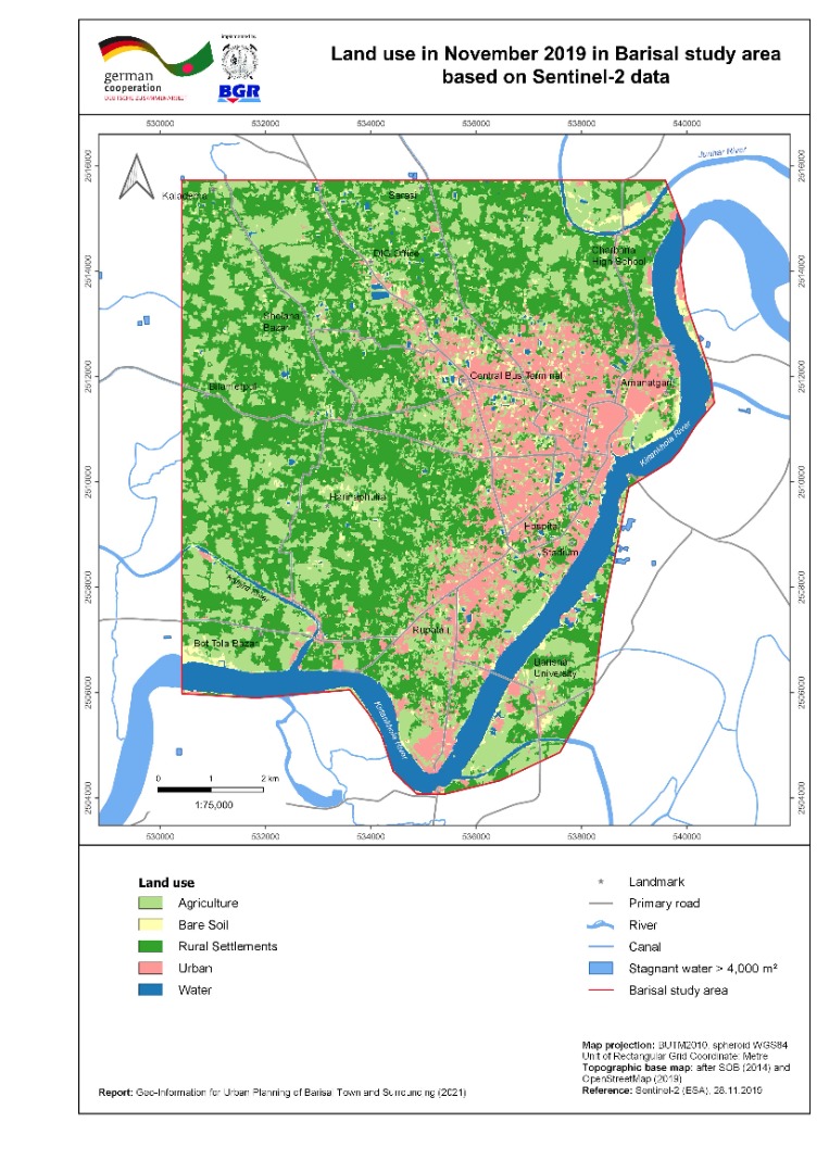 |
| ৮। | River Course Change Detection Map of Barishal Town and Surrounding Area | 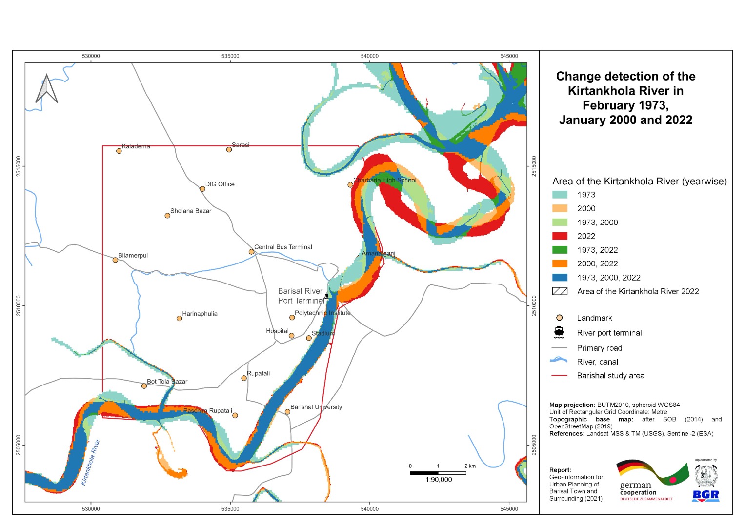 |
| ৯। | Vertical Ground Motion Map of Barishal Town and Surrounding Area | 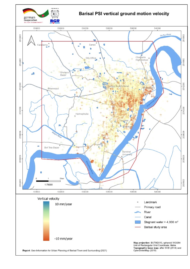 |
| ১০। | 3-D geological Model with cross section of Barishal Town and Surrounding Area |  |
| ১১। | Building Ground Suitability Map of Barishal Town and Surroundings | |
| ক্রমিক | মানচিত্রের নাম (খুলনা জোন ) | ভিউ/ ডাউনলোড |
| ১। | Local Peak Ground Acceleration (LPGA) Map of Khulna Town and Surrounding Area | 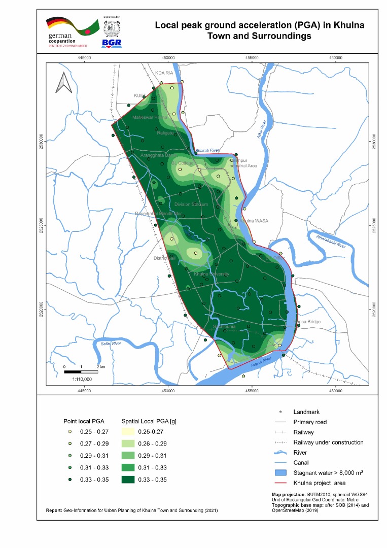 |
| ২। | Bearing Capacity Maps (shallow and deep foundation) of Khulna Town and Surrounding Area | 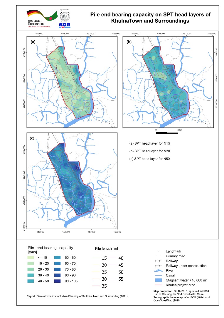 |
| ৩। | Liquefaction Potential Index (sLPI) Map of Faridpur Town and Surrounding Area | 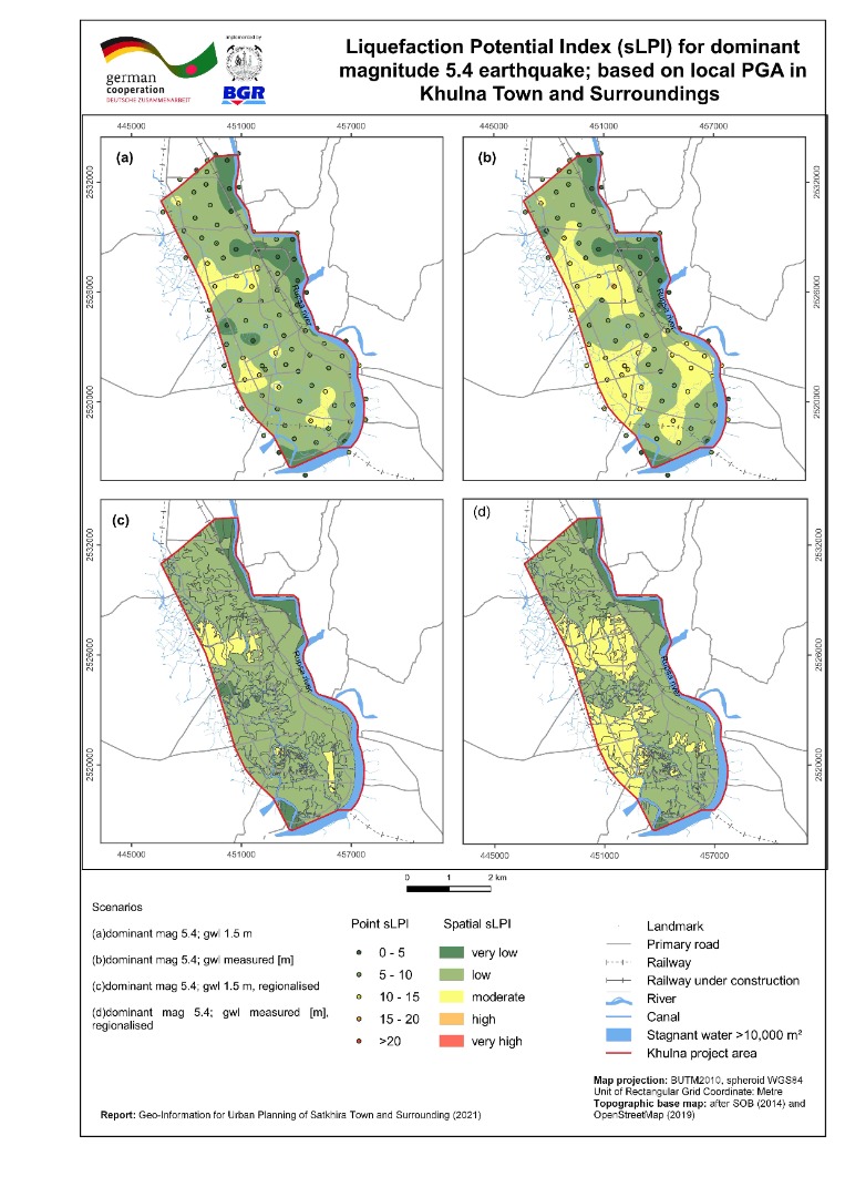 |
| ৪। | Seismic Site Class Map (Vs30) of Khulna Town and Surrounding Area | 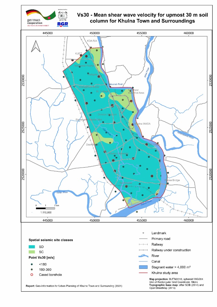 |
| ৫। | Geomorphic Map of Khulna Town and Surrounding Area | 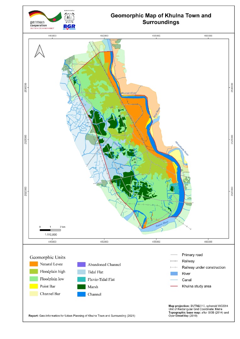 |
| ৬। | Inundation Map of Khulna Town and Surrounding Area | 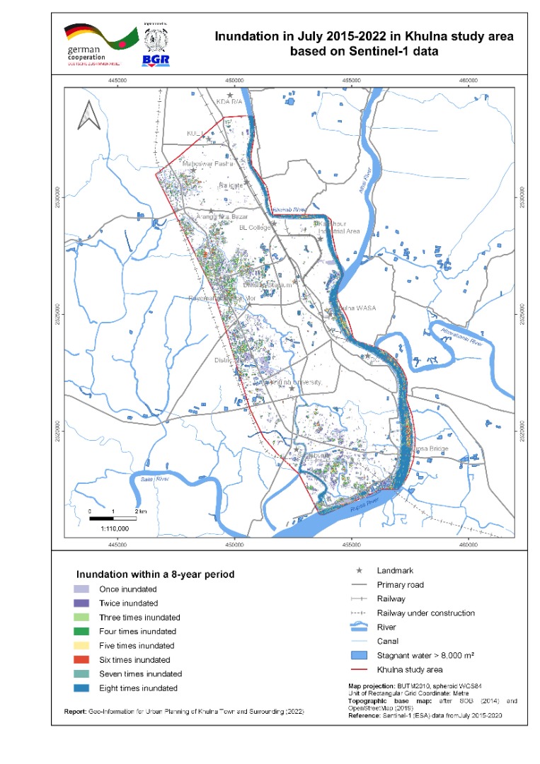 |
| ৭। | Land Use Map of Khulna Town and Surrounding Area | 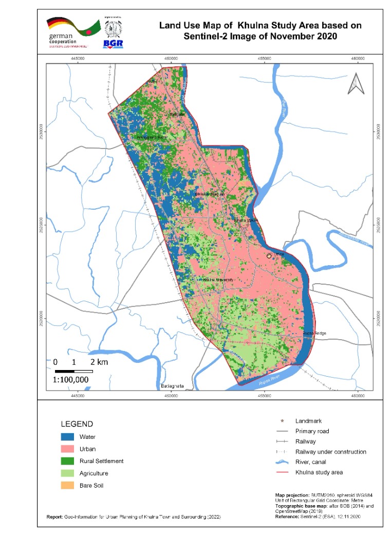 |
| ৮। | River Course Change Detection Map of Khulna Town and Surrounding Area | 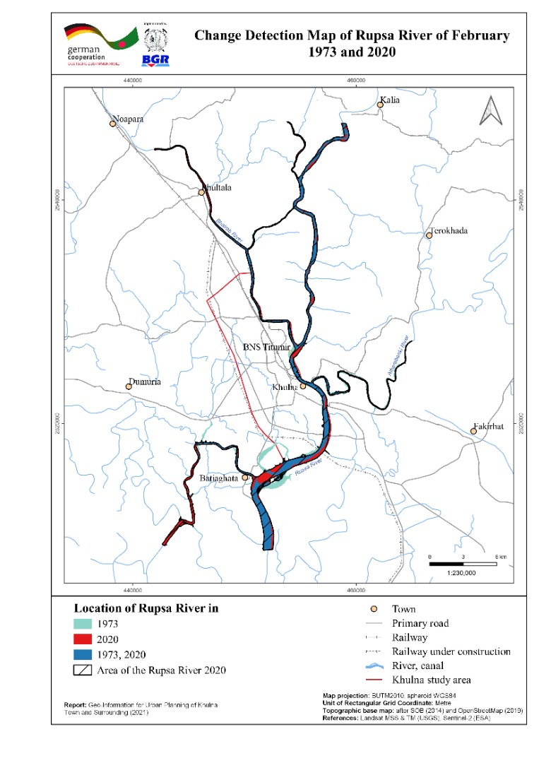 |
| ৯। | Vertical Ground Motion Map of Khulna Town and Surrounding Area | 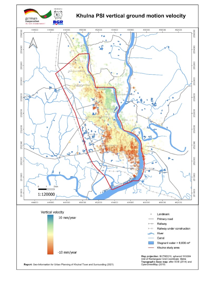 |
| ১০। | 3-D geological Model with cross section of Khulna Town and Surrounding Area |  |
| ১১। | Building Ground Suitability Mapof Khulna Town and Surroundings | |
| ক্রমিক | মানচিত্রের নাম (সাতক্ষীরা জোন ) | ভিউ/ ডাউনলোড |
| ১। | Local Peak Ground Acceleration (LPGA) Map of Satkhira Town and Surrounding Area | 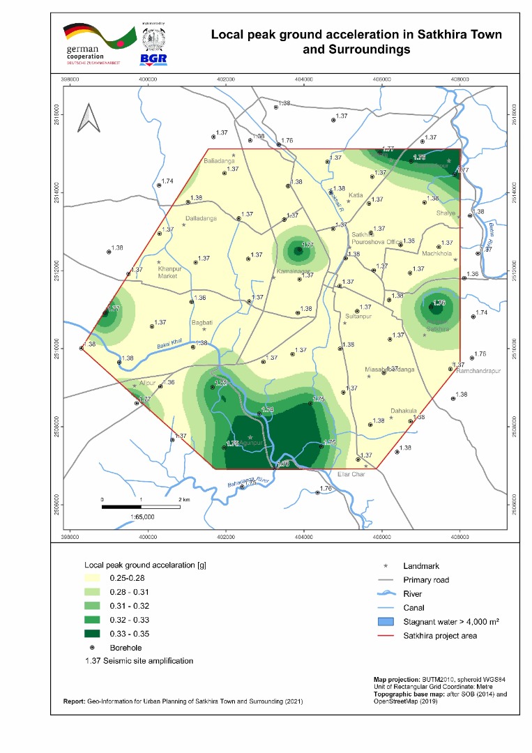 |
| ২। | Bearing capacity maps (shallow and deep foundation) of Satkhira Town and Surrounding Area |  |
| ৩। | Liquefaction Potential Index (sLPI) Map of Satkhira Town and Surrounding Area | 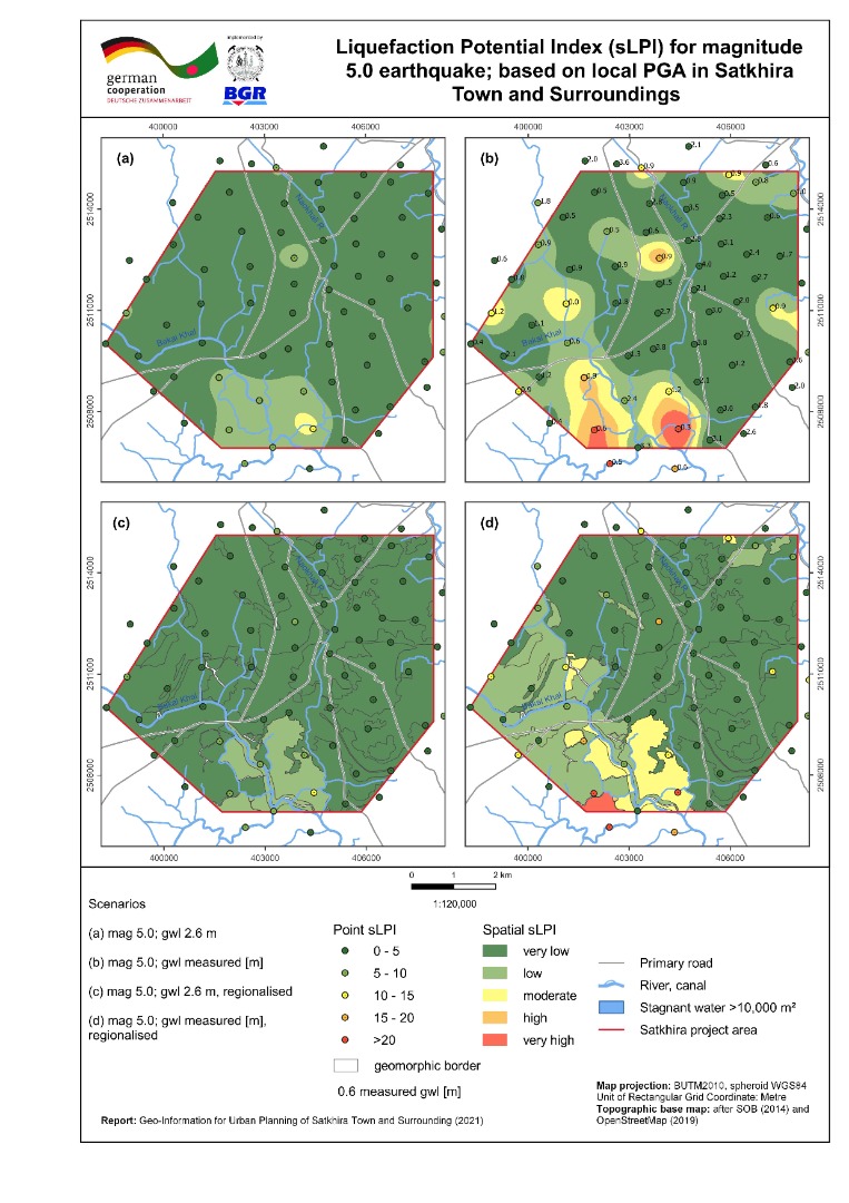 |
| ৪। | Seismic Site Class Map (Vs30) of Satkhira Town and Surrounding Area |  |
| ৫। | Geomorphic Map of Satkhira Town and Surrounding Area | 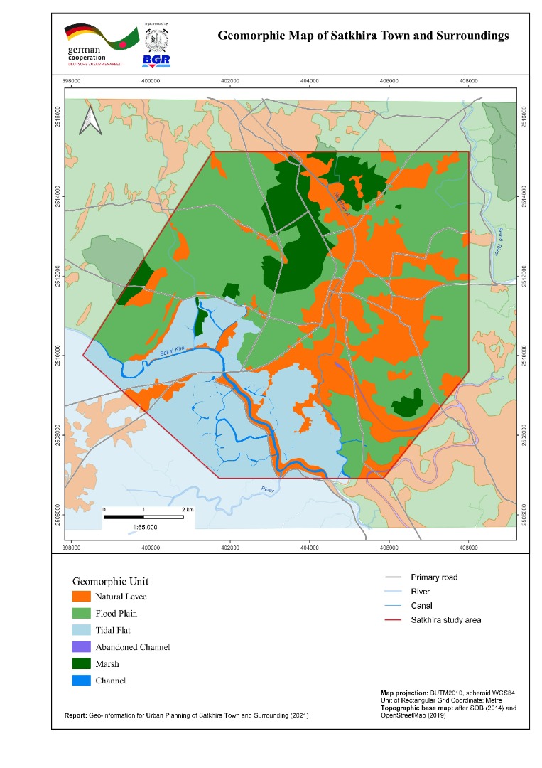 |
| ৬। | Inundation Map of Satkhira Town and Surrounding Area | 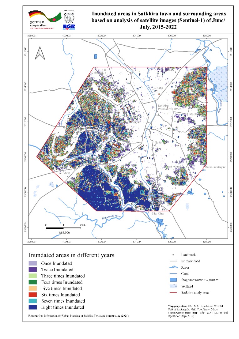 |
| ৭। | Land use map of Satkhira Town and Surrounding Area | 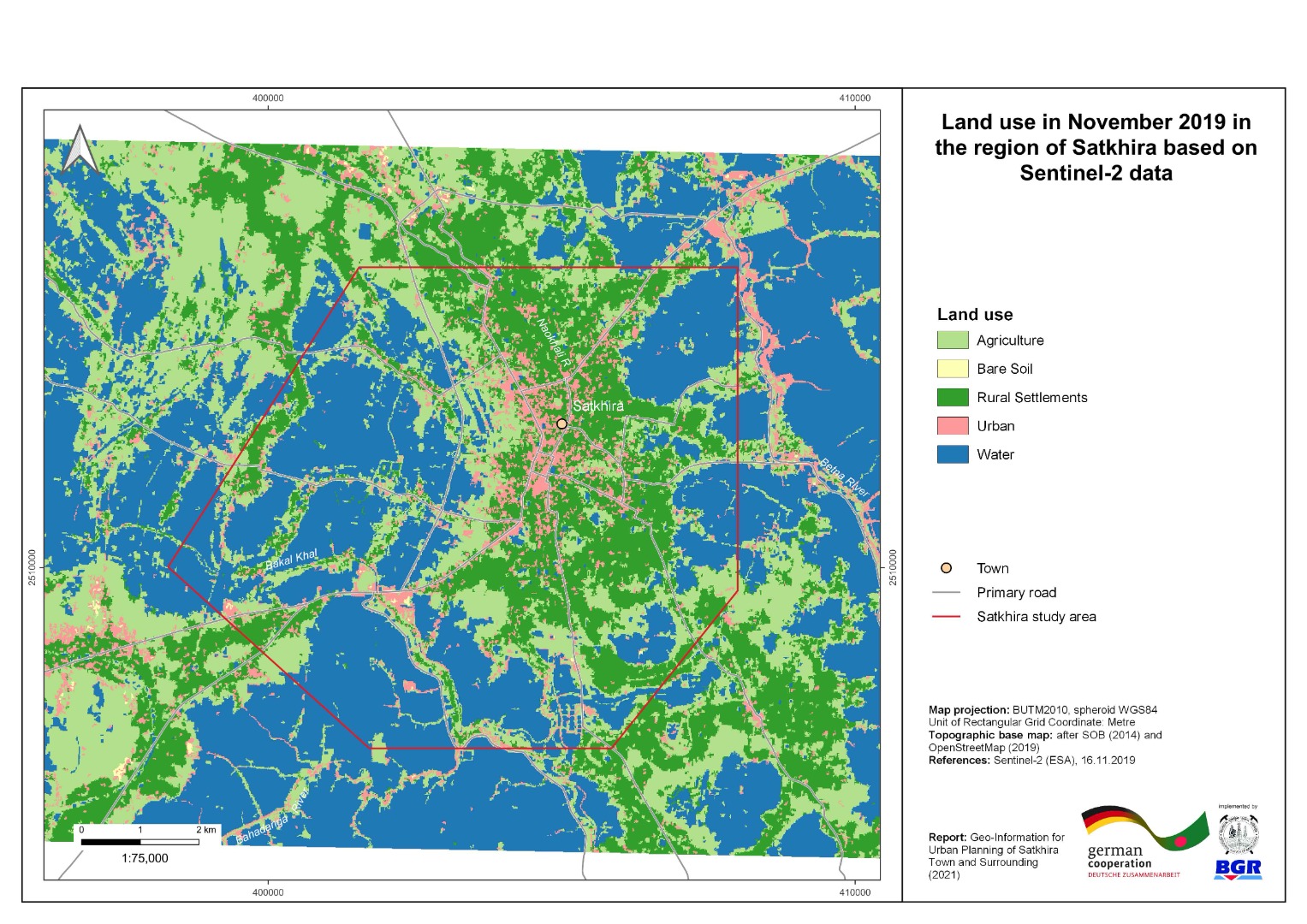 |
| ৮। | Vertical Ground Motion Map of Satkhira Town and Surrounding Area | 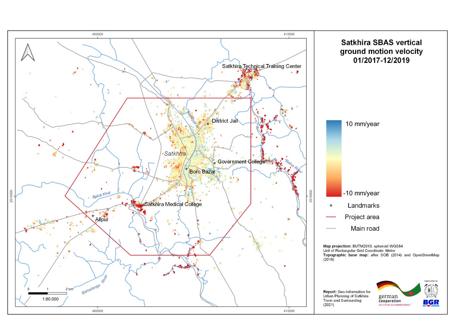 |
| ৯। | 3-D geological Model with cross-section of Satkhira Town and Surrounding Area | 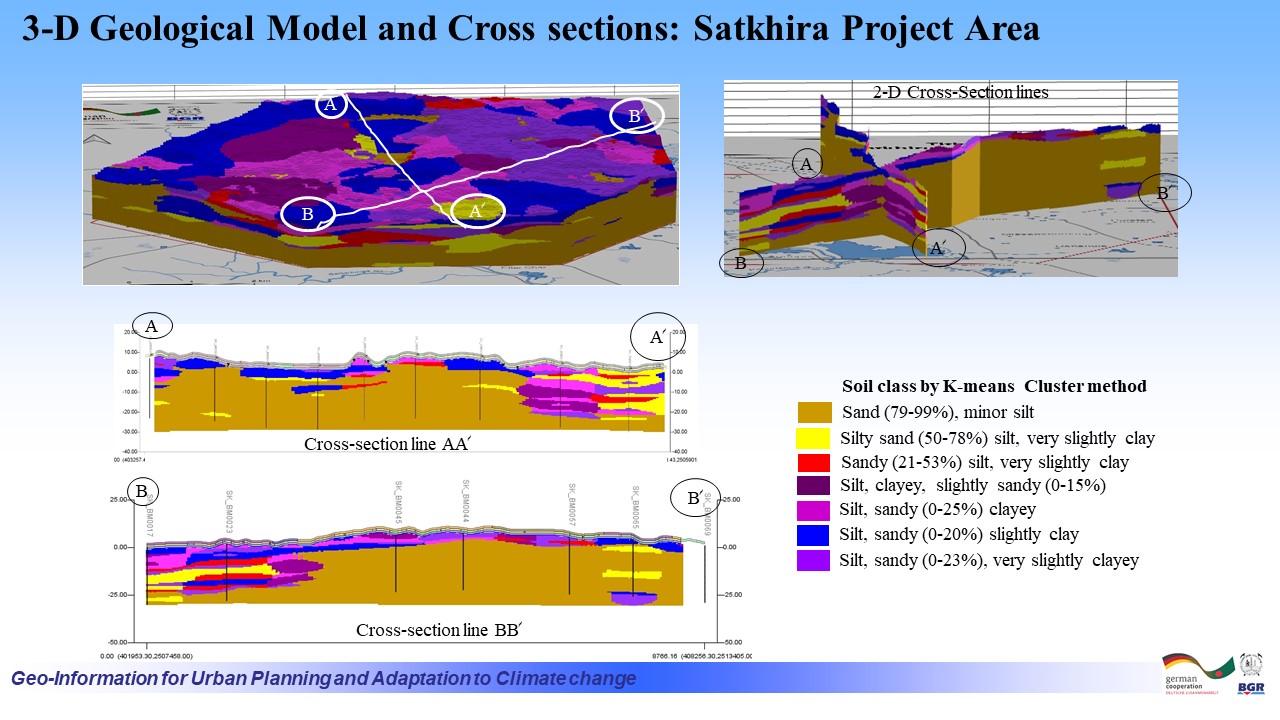 |
| ১০। | Building Ground Suitability Map of Satkhira Town and Surroundings | 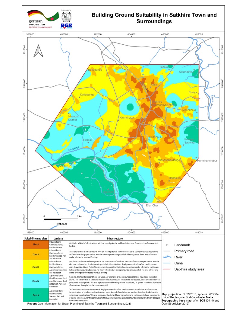 |
| ক্রমিক | অন্যান্য | ভিউ/ডাউনলোড |
| ১। | Regional Peak Ground Acceleration with 2% exceedance probability in 50 years, in and around Bangladesh |  |
| ২। | Regional Peak Ground Acceleration with 10% exceedance probability in 50 years, in and around Bangladesh | 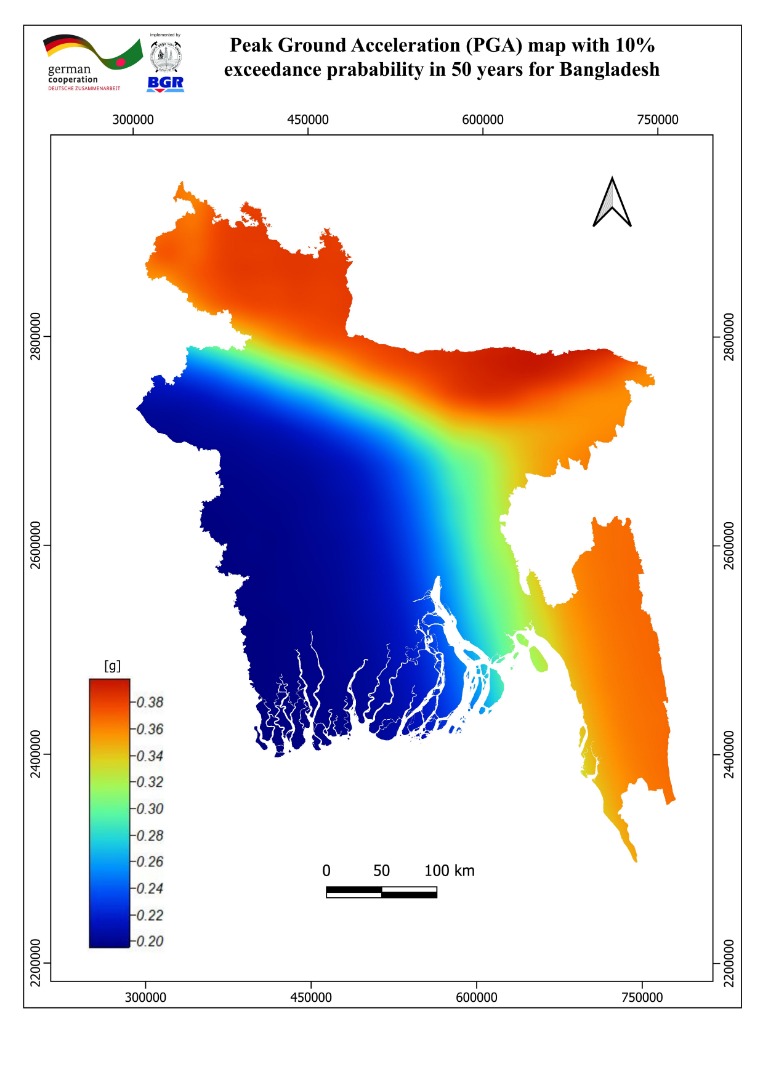 |
মাননীয় উপদেষ্টা

মুহাম্মদ ফাওজুল কবির খান
বিদ্যুৎ, জ্বালানি ও খনিজ সম্পদ মন্ত্রণালয়
সচিব

মোহাম্মদ সাইফুল ইসলাম
সচিব
জ্বালানি ও খনিজ সম্পদ বিভাগ
মহাপরিচালক

এস. এম. মঈন উদ্দীন আহম্মেদ
অতিরিক্ত সচিব (পরিকল্পনা)
জ্বালানি ও খনিজ সম্পদ বিভাগ
মহাপরিচালক
বাংলাদেশ ভূতাত্ত্বিক জরিপ অধিদপ্তর
বিস্তারিত...
কেন্দ্রীয় ই-সেবা
সর্বমোট হিট সংখ্যা
গুরুর্তপূর্ন লিঙ্ক সমূহ
- আইবাস++
- জ্বালানি ও খনিজ সম্পদ বিভাগ
- বিদ্যুৎ, জ্বালানি ও খনিজ সম্পদ মন্ত্রণালয়
- দুর্নীতি দমন কমিশন- হটলাইন#১০৬(টোল ফ্রি)

জাতীয় সংগীত

সামাজিক যোগাযোগ


ইনোভেশন কর্নার
জরুরি হেল্পলাইন নম্বর
